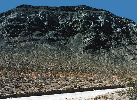
| Here is the type locality (where a geologic formation was first described in the scientific literature) of the Middle to Upper Devonian Lost Burro Formation, near the famous Lost Burro Mine at the southern end of Lost Burro Gap. The view here is west from the junction of Hunter Mountain Road and the primitive jeep track that takes off to Rest Spring Gulch. Roughly the lower one-third of the hillside--the entire hill is three inches high in the image-- is composed of the Silurian and Lower Devonian Hidden Valley Dolomite (which yields abundant corals and brachiopods);a little more than a third of the middle of the hill (one to two and a half inches from the base of the hill in the image) is the type locality for the Middle to Upper Devonian Lost Burro Formation--a stromatoporoid-rich sequence of dolomites, limestones, sandstones, quartzites and shales that also bears common brachiopods, crinoid debris, bryozoa, and an occasional gastropod. The topmost one-inch of the hill in the image is composed of dark blue limestones and shales belonging to the Lower Mississippian Tin Mountain limestone, an incredibly fossiliferous Paleozoic unit that contains an amazing diversity of solitary and colonial corals, gastropods, trilobites, ostracodes, brachiopods, crinoids, bryozoans and goniatitic ammonoids. |